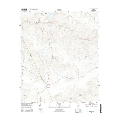
2014 Map of Massey Hill
USGS Topo · Published 2014About this map
The boundary between Wilkinson Co and Twiggs Co bisects this landscape, where the kaolin industry and small family settlements have long coexisted. The Freeport Kaolin Tailings Pond near Gordon points to the industrial footprint in the northern hills, while the southern terrain is defined by the winding course of Big Sandy Cr and Myricks Millpond. This area is particularly dense with genealogical landmarks, featuring more than a dozen burial grounds including Ramah Cem, the Augusta Fountain Cem, and the Branan Vinson Cem. The transportation network relies on rural routes like Fountain Rd and Asbury Church Rd, crossing local waters at landmarks like the H A Fountain Bridge. The map records a rural Georgia landscape where established family names are preserved through numerous cemeteries and isolated settlements like Massey Hill and Clayfields.
Find a feature on this map
46 named features on this map. Tap any name to fly to it.
Don’t see what you’re looking for? This feature index may not catch every label — zoom into the map to look around manually.
Map Details
Editions of this 2014 Massey Hill Map
This is the sole edition of this map. No revisions or reprints were ever made.
Other maps of this area

1916 · Irwinton
USGS Topo · 1:62,500

1920 · Irwinton
USGS Topo · 1:62,500

1956 · Gordon
USGS Topo · 1:62,500

1956 · Jeffersonville
USGS Topo · 1:62,500

1957 · Macon
USGS Topo · 1:250,000

1958 · Macon
USGS Topo · 1:250,000

1964 · Macon
USGS Topo · 1:250,000
1973 · Gordon
USGS Topo · 1:24,000

1973 · Massey Hill
USGS Topo · 1:24,000
1973 · Napier Pond
USGS Topo · 1:24,000