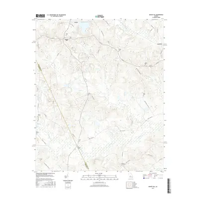
2017 Map of Massey Hill
USGS Topo · Published 2017About this map
Gordon sits at the northern edge of this Wilkinson County landscape, where industrial activity is marked by the Freeport Kaolin Tailings Pond. The map reveals a dense network of family and community history through its numerous burial grounds, including the Massey Cem, Ramah Cem, and McArthur-Robinson Cem. The terrain is defined by a series of south-flowing drainages like Dry Fork, Clear Cr, and Big Sandy Cr, which flow toward the border of Wilkinson Co and Twiggs Co. Local landmarks like Myricks Millpond and the H A Fountain Bridge over the Big Sandy reflect the intersection of the natural water system with early rural infrastructure. Further south, settlements like Clayfields and Massey Hill are connected by a web of local routes such as Kaolin RD and Asbury Church RD, tracing the agricultural and industrial character of the region in the early 21st century.
Find a feature on this map
52 named features on this map. Tap any name to fly to it.
Don’t see what you’re looking for? This feature index may not catch every label — zoom into the map to look around manually.
Map Details
Editions of this 2017 Massey Hill Map
This is the sole edition of this map. No revisions or reprints were ever made.
Other maps of this area

1916 · Irwinton
USGS Topo · 1:62,500

1920 · Irwinton
USGS Topo · 1:62,500

1956 · Gordon
USGS Topo · 1:62,500

1956 · Jeffersonville
USGS Topo · 1:62,500

1957 · Macon
USGS Topo · 1:250,000

1958 · Macon
USGS Topo · 1:250,000

1964 · Macon
USGS Topo · 1:250,000
1973 · Gordon
USGS Topo · 1:24,000

1973 · Massey Hill
USGS Topo · 1:24,000
1973 · Napier Pond
USGS Topo · 1:24,000