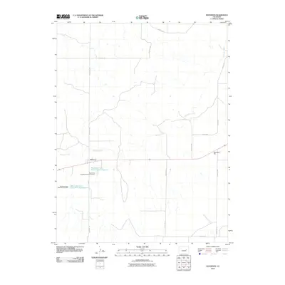
2010 Map of Matheson
USGS Topo · Published 2010About this map
Matheson stands as the central settlement in this portion of Elbert County, positioned where Main St meets the regional transit corridor. The surrounding landscape is defined by the ephemeral flow of Big Sandy Creek, which winds through the territory toward the east. This 2010 topographic record highlights the importance of water management in the arid Colorado plains, evidenced by significant infrastructure such as the Big Sandy Creek Watershed S-23 Dam and the Big Sandy Creek Watershed S-22 Dam. These structures create essential local water stores including the Big Sandy Creek Watershed S-23 Reservoir and Big Sandy Creek Watershed S-22 Reservoir. To the northeast, Matheson Hill provides a distinct topographic landmark overlooking the network of county roads, while North Rush Creek drains the southeastern corner of the quadrangle.
Find a feature on this map
18 named features on this map. Tap any name to fly to it.
Don’t see what you’re looking for? This feature index may not catch every label — zoom into the map to look around manually.
Map Details
Editions of this 2010 Matheson Map
This is the sole edition of this map. No revisions or reprints were ever made.
Other maps of this area

1891 · Limon
USGS Topo · 1:125,000

1892 · Limon
USGS Topo · 1:125,000

1953 · Denver
USGS Topo · 1:250,000

1954 · Limon
USGS Topo · 1:250,000

1957 · Denver
USGS Topo · 1:250,000

1957 · Limon
USGS Topo · 1:250,000

1958 · Limon
USGS Topo · 1:250,000

1958 · Denver
USGS Topo · 1:250,000

1960 · Denver
USGS Topo · 1:250,000
1970 · Matheson SW
USGS Topo · 1:24,000