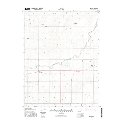
2016 Map of Matheson
USGS Topo · Published 2016About this map
Matheson serves as the focal point of this Elbert County landscape, situated where Broadway Ave meets the north-south corridor of Co Rd 149. The topography is defined by the winding path of Big Sandy Creek, which carves through the high plains terrain alongside Matheson Hill. Water management is a visible priority in this part of Colorado, evidenced by the Big Sandy Cr Watershed S-23 Reservoir and the Big Sandy Creek Watershed S-22 Reservoir located south of the main settlement. These reservoirs, alongside drainage features like Willow Gulch and N Rush Cr, illustrate the specialized infrastructure required to support life and agriculture in this semi-arid region. The map also traces a network of rural routes including Resolis Rd and Co Rd 102, which link the isolated homesteads and ranch lands that characterize the area.
Find a feature on this map
21 named features on this map. Tap any name to fly to it.
Don’t see what you’re looking for? This feature index may not catch every label — zoom into the map to look around manually.
Map Details
Editions of this 2016 Matheson Map
This is the sole edition of this map. No revisions or reprints were ever made.
Other maps of this area

1891 · Limon
USGS Topo · 1:125,000

1892 · Limon
USGS Topo · 1:125,000

1953 · Denver
USGS Topo · 1:250,000

1954 · Limon
USGS Topo · 1:250,000

1957 · Denver
USGS Topo · 1:250,000

1957 · Limon
USGS Topo · 1:250,000

1958 · Limon
USGS Topo · 1:250,000

1958 · Denver
USGS Topo · 1:250,000

1960 · Denver
USGS Topo · 1:250,000
1970 · Matheson SW
USGS Topo · 1:24,000