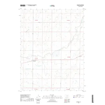
2019 Map of Matheson
USGS Topo · Published 2019About this map
Matheson serves as the central hub of this eastern Colorado landscape, situated along Broadway Ave where it intersects with local routes like Co RD 149. The area's hydrology is dominated by the meandering course of Big Sandy Creek, which flows southeastward across the plains. This 2019 survey documents modern water management features critical to the region's agricultural character, specifically the Big Sandy Cr Watershed S-22 Reservoir and its counterpart, the S-23 Reservoir. The terrain rises to the east at Matheson Hill, while drainage patterns are further defined by Willow Gulch in the northwest and N Rush Cr in the southeast corner. The grid of county roads, including Co RD 102 and Resolis Rd, illustrates the persistent township and range system that continues to organize this rural expanse.
Find a feature on this map
21 named features on this map. Tap any name to fly to it.
Don’t see what you’re looking for? This feature index may not catch every label — zoom into the map to look around manually.
Map Details
Editions of this 2019 Matheson Map
This is the sole edition of this map. No revisions or reprints were ever made.
Other maps of this area

1891 · Limon
USGS Topo · 1:125,000

1892 · Limon
USGS Topo · 1:125,000

1953 · Denver
USGS Topo · 1:250,000

1954 · Limon
USGS Topo · 1:250,000

1957 · Denver
USGS Topo · 1:250,000

1957 · Limon
USGS Topo · 1:250,000

1958 · Limon
USGS Topo · 1:250,000

1958 · Denver
USGS Topo · 1:250,000

1960 · Denver
USGS Topo · 1:250,000
1970 · Matheson SW
USGS Topo · 1:24,000