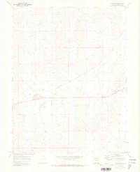
1970 Map of Matheson
USGS Topo · Published 1973About this map
Matheson serves as the primary focal point of this Eastern Colorado landscape, situated along the diagonal route of the Chicago Rock Island and Pacific railroad. The town's local infrastructure is clearly defined, featuring a Storage Bin and nearby Radio Towers on the higher ground of Matheson Hill. The surrounding terrain is shaped by the drainage patterns of Big Sandy Creek and Willow Gulch, which cut through the high plains. A small Gravel Pit and several named topographic features like Lasater and View suggest a land primarily used for ranching and transport during the early 1970s. The presence of water management features, including a Spillway and Riser, indicates the careful control of seasonal runoff in this semi-arid region, highlighting the engineering required to sustain local agriculture and the railroad corridor.
Find a feature on this map
14 named features on this map. Tap any name to fly to it.
Don’t see what you’re looking for? This feature index may not catch every label — zoom into the map to look around manually.
Map Details
Editions of this 1970 Matheson Map
This is the sole edition of this map. No revisions or reprints were ever made.
Other maps of this area

1891 · Limon
USGS Topo · 1:125,000

1892 · Limon
USGS Topo · 1:125,000

1953 · Denver
USGS Topo · 1:250,000

1954 · Limon
USGS Topo · 1:250,000

1957 · Denver
USGS Topo · 1:250,000

1957 · Limon
USGS Topo · 1:250,000

1958 · Limon
USGS Topo · 1:250,000

1958 · Denver
USGS Topo · 1:250,000

1960 · Denver
USGS Topo · 1:250,000
1970 · Matheson SW
USGS Topo · 1:24,000