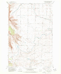
1975 Map of Mathews Corner
USGS Topo · Published 1977About this map
Taylor Flats defines the central topography of this mid-1970s survey, illustrating a landscape defined by industrial-scale irrigation and deep coulees. The map details the intricate water management infrastructure of Franklin County, highlighting the Potholes Canal and the Eltopia Branch Canal as they navigate the plateau. Smaller settlements and agricultural hubs like Mathews Corner and Baxter appear alongside vital rural infrastructure, including the Ringold Pumping Plant and Baxter Substation. To the west, the terrain drops sharply into the dramatic breaks of Parsons Canyon and Baxter Canyon, where the Wasteway channels water through the rugged relief. Traces of local community life are preserved in the location of Markham Sch, while an extensive network of family and farm-to-market roads like Sagemoor Road and Eltopia Road connect the subdivided sections.
Find a feature on this map
44 named features on this map. Tap any name to fly to it.
Don’t see what you’re looking for? This feature index may not catch every label — zoom into the map to look around manually.
Map Details
Editions of this 1975 Mathews Corner Map
This is the sole edition of this map. No revisions or reprints were ever made.
Other maps of this area

1917 · Pasco
USGS Topo · 1:125,000

1924 · Hanford
USGS Topo · 1:62,500

1925 · Scooteney Lake
USGS Topo · 1:62,500

1951 · Scooteney Lake
USGS Topo · 1:62,500

1951 · Richland
USGS Topo · 1:62,500

1951 · Hanford
USGS Topo · 1:62,500

1953 · Walla Walla
USGS Topo · 1:250,000

1958 · Walla Walla
USGS Topo · 1:250,000

1965 · Mesa
USGS Topo · 1:62,500

1965 · Eltopia
USGS Topo · 1:62,500