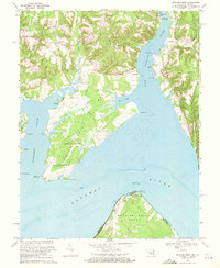
1968 Map of Mathias Point
USGS Topo · Published 1971About this map
The Potomac River dominates this mid-century coastal survey, where the Maryland and Virginia state lines meet along the water's edge. The landscape is defined by its deep estuaries and prominent landforms, notably Cedar Point Neck and Mathias Point Neck. The late 1960s found this region serving critical federal interests, evidenced by the expansive facilities of the U S Naval Research Laboratory and Harry Diamond Laboratories near Blossom Pt. Inland, the rural character of Charles County is preserved in small communities like Welcome and Hill Top, connected by roads such as Annapolis Woods Road. Maritime life is centered around the Port Tobacco River, where the Port Tobacco Marina and historic sites like St Ignatius Ch overlook the water, reflecting a shoreline that balances recreation, defense, and long-standing local heritage.
Find a feature on this map
51 named features on this map. Tap any name to fly to it.
Don’t see what you’re looking for? This feature index may not catch every label — zoom into the map to look around manually.
Map Details
Editions of this 1968 Mathias Point Map
2 editions found
Other maps of this area

1889 · Fredericksburg
USGS Topo · 1:125,000

1890 · Mt. Vernon
USGS Topo · 1:125,000

1891 · Mt. Vernon
USGS Topo · 1:125,000

1892 · Fredericksburg
USGS Topo · 1:125,000

1892 · Brandywine
USGS Topo · 1:62,500

1894 · Wicomico
USGS Topo · 1:62,500

1894 · Fredericksburg
USGS Topo · 1:125,000

1894 · Mt. Vernon
USGS Topo · 1:125,000

1895 · Wicomico
USGS Topo · 1:62,500

1895 · Brandywine
USGS Topo · 1:62,500