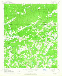
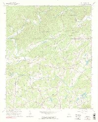
1964 Map of Matt
USGS Topo · Published 1965About this map
The Etowah River snakes across the northern border of this Georgia landscape, defining the boundary between Dawson and Forsyth counties. Much of the northern terrain is occupied by the US Air Force Reservation, while the surrounding countryside is dotted with small rural nodes like Matt, Heardville, and Barrettsville. This era captures the region before extensive suburbanization, characterized by a dense network of family-named roads and agrarian landmarks. Local history is centered on landmarks such as the Covered Bridge over Settingdown Creek and several country churches with adjacent burial grounds, including Mt Tabor Ch and Pleasant Grove Cem. The presence of Drag Strip Road and various Gravel Pits reflects the local economy and social life of the mid-1960s, providing a clear record of the area's physical and cultural geography prior to major modern development.
Find a feature on this map
54 named features on this map. Tap any name to fly to it.
Don’t see what you’re looking for? This feature index may not catch every label — zoom into the map to look around manually.
Map Details
Editions of this 1964 Matt Map
5 editions found
Other maps of this area

1890 · Suwanee
USGS Topo · 1:125,000

1894 · Suwanee
USGS Topo · 1:125,000

1926 · Tate
USGS Topo · 1:62,500

1928 · Tate
USGS Topo · 1:62,500

1955 · Rome
USGS Topo · 1:250,000

1956 · Birmingham
USGS Topo · 1:24,000

1958 · Rome
USGS Topo · 1:250,000

1961 · Rome
USGS Topo · 1:250,000

1963 · Rome
USGS Topo · 1:250,000
1964 · Juno
USGS Topo · 1:24,000