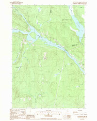
1988 Map of Mattaseunk Lake
USGS Topo · Published 1988About this map
The Penobscot River cuts through the heart of this Maine timberland, serving as a boundary between the townships of Medway, Woodville, and Mattawamkeag. In the late 1980s, this landscape was defined by its water power and industrial infrastructure, notably the Mattaseunk Dam and its adjacent Substation and Gaging Station. Near the eastern bend of the river, the small settlement of Jordan Mills stands at the edge of the wilderness, while further north, the expansive Mattaseunk Lake stretches across the Aroostook and Penobscot County line.
Find a feature on this map
30 named features on this map. Tap any name to fly to it.
Don’t see what you’re looking for? This feature index may not catch every label — zoom into the map to look around manually.
Map Details
Editions of this 1988 Mattaseunk Lake Map
This is the sole edition of this map. No revisions or reprints were ever made.
Other maps of this area

1920 · Winn
USGS Topo · 1:62,500

1940 · Mattawamkeag
USGS Topo · 1:62,500

1942 · Lincoln
USGS Topo · 1:62,500

1942 · Mattawamkeag
USGS Topo · 1:62,500

1951 · Millinocket
USGS Topo · 1:62,500

1954 · Millinocket
USGS Topo · 1:250,000

1957 · Lincoln
USGS Topo · 1:62,500

1958 · Millinocket
USGS Topo · 1:250,000

1960 · Millinocket
USGS Topo · 1:250,000
1960 · Winn
USGS Topo · 1:62,500