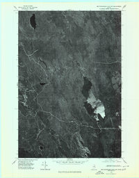
1975 Map of Mattawamkeag Lake SW
USGS Topo · Published 1980About this map
Wytopitlock Lake dominates this orthophotoquad, serving as a central landmark in a heavily forested landscape defined by its intricate drainage patterns. Created from aerial photography taken in the mid-1970s, this document provides a photographic record of the terrain as it existed before modern shifts in land management. The winding paths of Wytopitlock Stream and Macwahoc Stream carve through the dense timberland, revealing the natural hydrology that has long influenced the region's logging history and seasonal access. Smaller tributaries like Braley Brook and Orcutt Brook branch into the interior, highlighting the isolation and raw character of this part of Aroostook County. Unlike traditional line maps, the imagery here allows for the direct observation of forest density and natural clearings around the water bodies.
Find a feature on this map
5 named features on this map. Tap any name to fly to it.
Don’t see what you’re looking for? This feature index may not catch every label — zoom into the map to look around manually.
Map Details
Editions of this 1975 Mattawamkeag Lake SW Map
2 editions found
Other maps of this area

1940 · Sherman
USGS Topo · 1:62,500

1940 · Mattawamkeag
USGS Topo · 1:62,500

1941 · Mattawamkeag Lake
USGS Topo · 1:62,500

1941 · Wytopitlock
USGS Topo · 1:62,500

1942 · Mattawamkeag
USGS Topo · 1:62,500

1942 · Sherman
USGS Topo · 1:62,500

1943 · Wytopitlock
USGS Topo · 1:62,500

1943 · Mattawamkeag Lake
USGS Topo · 1:62,500

1954 · Millinocket
USGS Topo · 1:250,000

1958 · Millinocket
USGS Topo · 1:250,000