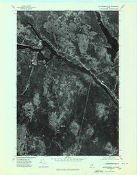
1975 Map of Mattawamkeag SW
USGS Topo · Published 1980About this map
The Penobscot River winds through this mid-1970s orthophotoquad, serving as a primary corridor for the region's timber-driven landscape. This unique photographic survey, produced by the Geological Survey, provides an overhead perspective of the terrain just as it appeared in late 1975. Along the riverbank, the settlement at Jordan Mills represents a small center of activity in an otherwise heavily forested area. To the northeast, the waters of Mattaseunk Lake and the feeder waters of Salmon Stream are clearly visible, with the photographic detail highlighting the density of the woods and the pathways of old roads or logging trails that cut through the Maine interior. This map is particularly valuable for identifying clearings and land use patterns that traditional topographic line maps might omit.
Find a feature on this map
4 named features on this map. Tap any name to fly to it.
Don’t see what you’re looking for? This feature index may not catch every label — zoom into the map to look around manually.
Map Details
Editions of this 1975 Mattawamkeag SW Map
This is the sole edition of this map. No revisions or reprints were ever made.
Other maps of this area

1920 · Winn
USGS Topo · 1:62,500

1940 · Mattawamkeag
USGS Topo · 1:62,500

1942 · Lincoln
USGS Topo · 1:62,500

1942 · Mattawamkeag
USGS Topo · 1:62,500

1951 · Millinocket
USGS Topo · 1:62,500

1954 · Millinocket
USGS Topo · 1:250,000

1957 · Lincoln
USGS Topo · 1:62,500

1958 · Millinocket
USGS Topo · 1:250,000

1960 · Millinocket
USGS Topo · 1:250,000
1960 · Winn
USGS Topo · 1:62,500