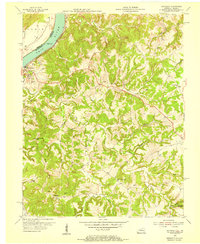
1953 Map of Mattingly
USGS Topo · Published 1955About this map
Cloverport sits at the northern edge of this mid-century survey, tucked into the sharp bend of the Ohio River where the Louisville and Nashville railroad tracks follow the riverbank. This riverfront landscape transitions quickly into a network of dissected ridges and winding stream valleys. Small rural settlements like Mattingly and Balltown are centered around numerous country churches and family cemeteries, suggesting a landscape deeply rooted in local kinship.
Find a feature on this map
46 named features on this map. Tap any name to fly to it.
Don’t see what you’re looking for? This feature index may not catch every label — zoom into the map to look around manually.
Map Details
Editions of this 1953 Mattingly Map
This is the sole edition of this map. No revisions or reprints were ever made.
Other maps of this area

1928 · Hardinsburg
USGS Topo · 1:48,000

1931 · Hardinsburg
USGS Topo · 1:62,500

1932 · Fordsville
USGS Topo · 1:62,500

1934 · Cannelton
USGS Topo · 1:62,500

1947 · Lodiburg
USGS Topo · 1:24,000

1947 · Hardinsburg
USGS Topo · 1:24,000

1947 · Hardinsburg
USGS Topo · 1:62,500

1949 · Cannelton
USGS Topo · 1:24,000

1953 · Cannelton
USGS Topo · 1:24,000

1953 · Hardinsburg
USGS Topo · 1:24,000