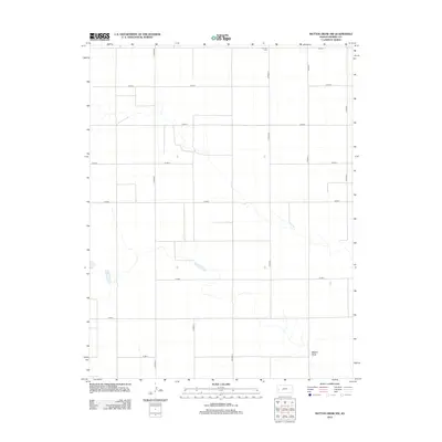
2012 Map of Mattox Draw NW
USGS Topo · Published 2012About this map
Mattox Draw defines the drainage patterns of this high plains landscape in Kearny County, where the terrain is marked by a rigorous section-line road grid. The map reveals the quiet, rural character of the region, centered on agricultural connectivity through routes like Co Road E and Co Road 8. Historical researchers and genealogists will find the Fairview Cem located near the northern boundary along Co Road 2, a significant marker of early settlement and community in this part of western Kansas. The sparse distribution of named features emphasize the isolation and open character of the land, where the intermittent waters of the draw and a few isolated stock ponds provide the only break in the geometric regularity of the county roads.
Find a feature on this map
16 named features on this map. Tap any name to fly to it.
Don’t see what you’re looking for? This feature index may not catch every label — zoom into the map to look around manually.
Map Details
Editions of this 2012 Mattox Draw NW Map
This is the sole edition of this map. No revisions or reprints were ever made.
Other maps of this area

1955 · Scott City
USGS Topo · 1:250,000

1958 · Scott City
USGS Topo · 1:250,000

1965 · Leoti 3 NW
USGS Topo · 1:24,000

1965 · Leoti 3 NE
USGS Topo · 1:24,000
1966 · Leoti 3 SW
USGS Topo · 1:24,000
1966 · Tribune 4 SE
USGS Topo · 1:24,000

1966 · Tribune 4 NE
USGS Topo · 1:24,000
1966 · Leoti 3 SE
USGS Topo · 1:24,000

1970 · Selkirk SE
USGS Topo · 1:24,000

1970 · Lydia
USGS Topo · 1:24,000