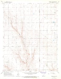
1966 Map of Tribune 4 SE
USGS Topo · Published 1967About this map
Shirley Creek carves a significant drainage through this high plains landscape on the border of Hamilton and Kearny Counties. The map illustrates a rural environment defined by large-scale township divisions including Liberty, Kendall, West Hibbard, and Hartland. Evidence of mid-century infrastructure and social life is found in the solitary Community Hall and a network of buried pipelines that traverse the open range. The presence of a Gas Well and another Well in the southern sections indicates the area's utility and resource development during the 1960s. This survey is particularly useful for understanding the exact positioning of property and township boundaries in a region where natural landmarks are scarce.
Find a feature on this map
10 named features on this map. Tap any name to fly to it.
Don’t see what you’re looking for? This feature index may not catch every label — zoom into the map to look around manually.
Map Details
Editions of this 1966 Tribune 4 SE Map
2 editions found
Other maps of this area

1891 · Larned
USGS Topo · 1:125,000

1900 · Syracuse
USGS Topo · 1:125,000

1900 · Lakin
USGS Topo · 1:125,000

1920 · Syracuse
USGS Topo · 1:125,000

1955 · Dodge City
USGS Topo · 1:250,000

1955 · Scott City
USGS Topo · 1:250,000

1958 · Dodge City
USGS Topo · 1:250,000

1958 · Scott City
USGS Topo · 1:250,000

1959 · Dodge City
USGS Topo · 1:250,000

1965 · Leoti 3 NW
USGS Topo · 1:24,000