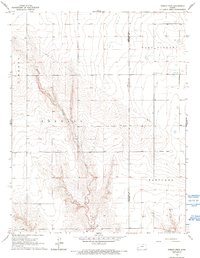
1966 Map of Shirley Creek
USGS Topo · Published 1993About this map
Shirley Creek carves a deep, winding path through this corner of western Kansas, defining the topographic character of the High Plains landscape. In the mid-1960s, this area straddled the border of Hamilton Co and Kearny Co, partitioned into the civil townships of Liberty, Kendall, West Hibbard, and Hartland. The map reveals a transition from traditional agricultural land use toward energy extraction, evidenced by a Pipeline cutting across the sections and several energy sites including a Gas Well and other scattered wells in the southern reaches. Social infrastructure is sparse but notable, centered on a lone Community Hall that served the rural families of the West Hibbard district. The fine red dashed lines throughout the map provide an intricate view of property boundaries, showing how the vast open plains were meticulously fenced and managed during this era of 20th-century ranching and farming.
Find a feature on this map
10 named features on this map. Tap any name to fly to it.
Don’t see what you’re looking for? This feature index may not catch every label — zoom into the map to look around manually.
Map Details
Editions of this 1966 Shirley Creek Map
2 editions found
Other maps of this area

1891 · Larned
USGS Topo · 1:125,000

1900 · Syracuse
USGS Topo · 1:125,000

1900 · Lakin
USGS Topo · 1:125,000

1920 · Syracuse
USGS Topo · 1:125,000

1955 · Dodge City
USGS Topo · 1:250,000

1955 · Scott City
USGS Topo · 1:250,000

1958 · Dodge City
USGS Topo · 1:250,000

1958 · Scott City
USGS Topo · 1:250,000

1959 · Dodge City
USGS Topo · 1:250,000

1965 · Leoti 3 NW
USGS Topo · 1:24,000