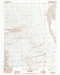
1982 Map of Maturango Peak SE
USGS Topo · Published 1983About this map
The Anthony Mill Ruins stand as a testament to the early industrial efforts in this arid landscape, situated on the western edge of the Panamint Valley. This 1982 provisional survey captures a terrain dominated by shifting geological features, where expansive stretches of Sand and the Alkali Flat create a stark, salt-crusted basin. The presence of the Panamint Valley Crater in the northwest corner highlights the volcanic history of the region, while modern extractive activity is evidenced by a Borrow Pit and various Quarries located across the valley floor. The map’s focus on elevation and drainage patterns reveals the environmental challenges of the Great Basin, mapping the complex alluvial fans that sweep down from the surrounding heights toward the low-lying flats.
Find a feature on this map
10 named features on this map. Tap any name to fly to it.
Don’t see what you’re looking for? This feature index may not catch every label — zoom into the map to look around manually.
Map Details
Editions of this 1982 Maturango Peak SE Map
This is the sole edition of this map. No revisions or reprints were ever made.
Other maps of this area

1908 · Ballarat
USGS Topo · 1:250,000

1913 · Ballarat
USGS Topo · 1:250,000

1915 · Searles Lake
USGS Topo · 1:250,000

1947 · Trona
USGS Topo · 1:250,000

1948 · Trona
USGS Topo · 1:250,000

1948 · Death Valley
USGS Topo · 1:250,000

1949 · Trona
USGS Topo · 1:62,500

1950 · Trona
USGS Topo · 1:62,500

1950 · Manly Peak
USGS Topo · 1:62,500
1951 · Manly Peak
USGS Topo · 1:62,500