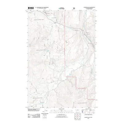
2011 Map of Maukey Gulch
USGS Topo · Published 2011About this map
McDonald Mine and several other extraction sites sit tucked within the gulches and canyons of this Granite County landscape. The topography is defined by the complex drainage network of Rock Creek, where the West Fork and Middle Fork converge. Resource extraction is a visible legacy here, with specific claims like the NE NE Section 6 Mine and Bentz Mine noted alongside the winding corridors of Rock Creek Rd and Ross's Fork Rd. In the southern reaches, Moose Meadows provides a distinct break in the terrain near the headwaters of Moose Meadow Creek. Smaller water features such as Milo Lake and the Stephens Reservoir suggest localized water management for mining or ranching, while the dramatic Eagle Canyon marks the eastern edge of the survey area.
Find a feature on this map
27 named features on this map. Tap any name to fly to it.
Don’t see what you’re looking for? This feature index may not catch every label — zoom into the map to look around manually.
Map Details
Editions of this 2011 Maukey Gulch Map
This is the sole edition of this map. No revisions or reprints were ever made.
Other maps of this area

1908 · Philipsburg
USGS Topo · 1:125,000

1909 · Sapphire
USGS Topo · 1:125,000

1947 · Butte
USGS Topo · 1:250,000

1958 · Butte
USGS Topo · 1:250,000

1960 · Butte
USGS Topo · 1:250,000

1962 · Butte
USGS Topo · 1:250,000

1971 · Antelope Creek
USGS Topo · 1:24,000

1971 · Potato Lakes
USGS Topo · 1:24,000
1971 · Carpp Ridge
USGS Topo · 1:24,000

1971 · Stony Creek
USGS Topo · 1:24,000