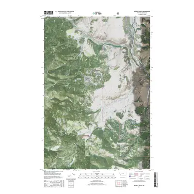
2017 Map of Maukey Gulch
USGS Topo · Published 2017About this map
The Deerlodge National Forest landscape in Granite County is defined by a dense network of high-elevation drainages and topographic landmarks. Tributaries such as Beaver Cr and W Fork Beaver Cr carve through the terrain, meeting at Stephens Reservoir. This 2017 survey reveals the distinct naming conventions of the Sapphire Mountains, with features like Maukey Gulch, Schoolmarm Gulch, and Sapphire Gulch indicating early cultural influences and land use. The primary thoroughfare, Skalkaho Rd, follows the northern ridges, while primitive routes like Co Rd 70 and Ross's Fork Rd provide access to the interior. High-elevation points like Lone Pine Ridge and the dramatic Eagle Canyon overlook a region shaped by glacial and hydraulic history, evidenced by the presence of Mito Lake and the wetlands of Moose Meadows.
Find a feature on this map
53 named features on this map. Tap any name to fly to it.
Don’t see what you’re looking for? This feature index may not catch every label — zoom into the map to look around manually.
Map Details
Editions of this 2017 Maukey Gulch Map
This is the sole edition of this map. No revisions or reprints were ever made.
Other maps of this area

1908 · Philipsburg
USGS Topo · 1:125,000

1909 · Sapphire
USGS Topo · 1:125,000

1947 · Butte
USGS Topo · 1:250,000

1958 · Butte
USGS Topo · 1:250,000

1960 · Butte
USGS Topo · 1:250,000

1962 · Butte
USGS Topo · 1:250,000

1971 · Antelope Creek
USGS Topo · 1:24,000

1971 · Potato Lakes
USGS Topo · 1:24,000
1971 · Carpp Ridge
USGS Topo · 1:24,000

1971 · Stony Creek
USGS Topo · 1:24,000