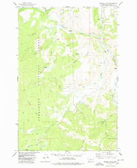
1978 Map of Maukey Gulch
USGS Topo · Published 1978About this map
Deerlodge National Forest dominates this Montana landscape, where the headwaters of Rock Creek and its many forks carve through the high country of Granite County. This 1970s record illustrates a wilderness managed for resource extraction and forestry, anchored by the West Fork Work Center and a network of primitive transportation routes including the Jeep Trail and Pack Trail.
Find a feature on this map
37 named features on this map. Tap any name to fly to it.
Don’t see what you’re looking for? This feature index may not catch every label — zoom into the map to look around manually.
Map Details
Editions of this 1978 Maukey Gulch Map
This is the sole edition of this map. No revisions or reprints were ever made.
Other maps of this area

1908 · Philipsburg
USGS Topo · 1:125,000

1909 · Sapphire
USGS Topo · 1:125,000

1947 · Butte
USGS Topo · 1:250,000

1958 · Butte
USGS Topo · 1:250,000

1960 · Butte
USGS Topo · 1:250,000

1962 · Butte
USGS Topo · 1:250,000

1971 · Antelope Creek
USGS Topo · 1:24,000

1971 · Potato Lakes
USGS Topo · 1:24,000
1971 · Carpp Ridge
USGS Topo · 1:24,000

1971 · Stony Creek
USGS Topo · 1:24,000