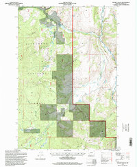
1996 Map of Maukey Gulch
USGS Topo · Published 1998About this map
Deer Lodge National Forest dominates this mountain landscape in Granite County, where the hydrological system of the Rock Creek drainage is documented in detail. The map shows the convergence of the West Fork Rock Creek and the Middle Fork Rock Creek, supporting a high-altitude environment defined by drainages like Maukey Gulch and Emerine Gulch. Industrial and administrative activity is evidenced by the McDonald Mine and the West Fork Work Center, suggesting the era's ongoing management of timber and mineral resources. Natural features such as Milo Lake and the expanse of Moose Meadows sit alongside human infrastructure like the Stephens Reservoir and a Gaging Station, illustrating the balance between wild forest land and the monitored flow of the region's vital water sources.
Find a feature on this map
33 named features on this map. Tap any name to fly to it.
Don’t see what you’re looking for? This feature index may not catch every label — zoom into the map to look around manually.
Map Details
Editions of this 1996 Maukey Gulch Map
This is the sole edition of this map. No revisions or reprints were ever made.
Other maps of this area

1908 · Philipsburg
USGS Topo · 1:125,000

1909 · Sapphire
USGS Topo · 1:125,000

1947 · Butte
USGS Topo · 1:250,000

1958 · Butte
USGS Topo · 1:250,000

1960 · Butte
USGS Topo · 1:250,000

1962 · Butte
USGS Topo · 1:250,000

1971 · Antelope Creek
USGS Topo · 1:24,000

1971 · Potato Lakes
USGS Topo · 1:24,000
1971 · Carpp Ridge
USGS Topo · 1:24,000

1971 · Stony Creek
USGS Topo · 1:24,000