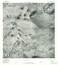
1978 Map of Mauna Kea
USGS Topo · Published 1981About this map
Mauna Kea dominates this high-altitude landscape on the Big Island, as seen in aerial photography captured between late 1976 and early 1978. This orthophotoquad provides a clear, photographic perspective of the volcanic terrain and its numerous cinder cones, including Puu Makanaka and Puu Kanakaleonui. Unlike traditional topographic maps, this record uses rectified imagery to show the actual surface texture and distribution of volcanic features across the summit area. The visual detail extends to Puu Haiwahine in the south and Puu Loa to the east, illustrating the complex geomorphology of this dormant shield volcano during the late twentieth century. Produced in cooperation with the State of Hawaii, the map captures the stark, unpopulated character of the mountain's upper reaches before further modernization.
Find a feature on this map
5 named features on this map. Tap any name to fly to it.
Don’t see what you’re looking for? This feature index may not catch every label — zoom into the map to look around manually.
Map Details
Editions of this 1978 Mauna Kea Map
This is the sole edition of this map. No revisions or reprints were ever made.
Other maps of this area

1927 · Kaohe
USGS Topo · 1:62,500

1930 · Humuula
USGS Topo · 1:62,500

1930 · Kaohe
USGS Topo · 1:62,500

1954 · Hawaii North
USGS Topo · 1:250,000

1956 · Puu Oo
USGS Topo · 1:24,000

1956 · Pua Akala
USGS Topo · 1:24,000

1956 · Puu Koli
USGS Topo · 1:24,000

1956 · Keanakolu
USGS Topo · 1:24,000

1956 · Upper Piihonua
USGS Topo · 1:24,000

1956 · Makahalau
USGS Topo · 1:24,000