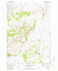
1981 Map of Maupin Butte
USGS Topo · Published 1981About this map
Ryegrass Ranch serves as a lone human footprint in this high desert landscape of central Oregon, situated between the vast elevations of Ryegrass Table and Twelvemile Table. The terrain is defined by dramatic volcanic features including Maupin Butte, Homestead Butte, and the appropriately named Milk Butte. Water sources are scarce but vital, marked by Maupin Spring, Odell Spring, and the artificial Summit Reservoir. The geological character of the region is further revealed through names like Fossil Ridge and the deep cuts of Twelvemile Canyon. To the north, Beaver Creek flows near Henry Rim, while a network of 4WD trails provides the only access through Congleton Hollow and across the ridgelines of Payne Ridge.
Find a feature on this map
22 named features on this map. Tap any name to fly to it.
Don’t see what you’re looking for? This feature index may not catch every label — zoom into the map to look around manually.
Map Details
Editions of this 1981 Maupin Butte Map
This is the sole edition of this map. No revisions or reprints were ever made.
Other maps of this area

1932 · Dayville
USGS Topo · 1:125,000

1936 · Dayville
USGS Topo · 1:125,000

1955 · Crescent
USGS Topo · 1:250,000

1955 · Bend
USGS Topo · 1:250,000

1955 · Burns
USGS Topo · 1:250,000

1955 · Canyon City
USGS Topo · 1:250,000

1957 · Crescent
USGS Topo · 1:250,000

1957 · Bend
USGS Topo · 1:250,000

1958 · Crescent
USGS Topo · 1:250,000

1958 · Burns
USGS Topo · 1:250,000