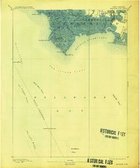
1891 Map of Maurice Cove
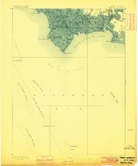
USGS Topo · Published 1913About this map
The maritime frontier of Cumberland County takes center stage in this late 19th-century survey of the Delaware Bay coastline. The settlement of Port Norris serves as a vital rail terminus, where the Cumberland & Maurice River R.R. and the West Jersey R.R. meet the water at Long Reach. This interface between land and sea is defined by a labyrinth of tidal waterways, including Dividing Creek and Oranoaken Creek, which navigate the marshy expanse of Downe and Commercial townships.
Find a feature on this map
38 named features on this map. Tap any name to fly to it.
Don’t see what you’re looking for? This feature index may not catch every label — zoom into the map to look around manually.
Map Details
Editions of this 1891 Maurice Cove Map
3 editions found
Other maps of this area

1888 · Cape May
USGS Topo · 1:62,500

1888 · Dennisville
USGS Topo · 1:62,500

1890 · Tuckahoe
USGS Topo · 1:62,500

1890 · Maurice Cove
USGS Topo · 1:62,500

1890 · Bay Side
USGS Topo · 1:62,500

1890 · Bridgeton
USGS Topo · 1:62,500

1891 · Maurice Cove
USGS Topo · 1:62,500

1893 · Cape May
USGS Topo · 1:62,500

1893 · Tuckahoe
USGS Topo · 1:62,500

1894 · Dennisville
USGS Topo · 1:62,500
Featured Places
- Maurice River Township, NJ
- Commercial Township, NJ
- Downe Township, NJ
- Port Norris, Commercial Township
- Bivalve, Commercial Township