
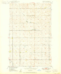
1949 Map of Maxbass
USGS Topo · Published 1949About this map
Maxbass serves as the primary hub of this North Dakota landscape, situated at the terminus of the Great Northern railroad line in the northern reaches of Hastings township. The 1940s topography reveals a grid-patterned agricultural region defined by townships like Mount Rose, Lewis, and Chatfield, where the Cut Bank Creek meanders southeast across the prairie. Small-town civic life is evident through the presence of the Town Hall and School No 1, which supported the dispersed farming community. Transportation was vital to the area's development, as evidenced by the second rail line, the Minneapolis Sault Ste Marie and St Paul, which cuts through the southern half of the map near the small settlement of Hurd. This survey captures the height of the mid-century grain-rail economy before the consolidation of rural infrastructure.
Find a feature on this map
12 named features on this map. Tap any name to fly to it.
Don’t see what you’re looking for? This feature index may not catch every label — zoom into the map to look around manually.
Map Details
Editions of this 1949 Maxbass Map
This is the sole edition of this map. No revisions or reprints were ever made.
Other maps of this area

1948 · Lansford
USGS Topo · 1:62,500

1949 · Glenburn
USGS Topo · 1:24,000

1949 · Lansford SE
USGS Topo · 1:24,000

1949 · Lansford NE
USGS Topo · 1:24,000

1949 · Eckman SE
USGS Topo · 1:24,000

1949 · Eckman
USGS Topo · 1:24,000

1949 · Westhope SW
USGS Topo · 1:24,000

1950 · Lansford
USGS Topo · 1:62,500

1950 · Westhope SW
USGS Topo · 1:24,000
1950 · Renville
USGS Topo · 1:24,000