
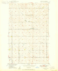
1949 Map of Westhope SW
USGS Topo · Published 1966About this map
Glacial prairie potholes and subtle topographic depressions define this corner of Bottineau County, surveyed in the late 1940s as part of the Missouri River Basin development program. The landscape is organized by the rigid township and range system, which at this time supported a sparse network of rural institutions like Zion Ch and the district school system. This specific area highlights the presence of Stinson Sch No 3 and Stinson Sch No 1, which served the farming communities across the townships of Bentinck, Hastings, Reneville, and Sherman. The map provides an exceptionally clear view of the complex wetland drainage patterns and small seasonal basins that characterize this North Dakota terrain before widespread modern agricultural land-leveling changed many such features.
Find a feature on this map
8 named features on this map. Tap any name to fly to it.
Don’t see what you’re looking for? This feature index may not catch every label — zoom into the map to look around manually.
Map Details
Editions of this 1949 Westhope SW Map
This is the sole edition of this map. No revisions or reprints were ever made.
Other maps of this area

1948 · Lansford
USGS Topo · 1:62,500

1949 · Lansford NE
USGS Topo · 1:24,000

1949 · Maxbass
USGS Topo · 1:24,000

1949 · Eckman
USGS Topo · 1:24,000

1950 · Lansford
USGS Topo · 1:62,500

1950 · Westhope SW
USGS Topo · 1:24,000

1950 · Antler
USGS Topo · 1:24,000
1950 · Renville
USGS Topo · 1:24,000

1951 · Westhope SE
USGS Topo · 1:24,000
1951 · Kuroki
USGS Topo · 1:24,000