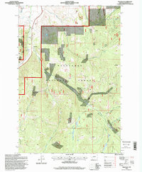
1996 Map of Maxville
USGS Topo · Published 1998About this map
Maxville and the nearby settlement of Princeton anchor this mid-1990s survey of Granite County, where mining interests and timber management define the landscape within the Deerlodge National Forest. The topography is dominated by steep drainage systems like Wyman Gulch and Swamp Gulch, which feed into major water bodies including Flint Creek and Boulder Creek. The map provides a detailed record of high-altitude extraction sites, from the Royal Basin Mine to the Gold Hill Mine and numerous nameless strip mines along the northern ridges. Significant landmarks such as Mount Princeton and Douglas Mountain overlook a complex network of forest roads and trails used by the Philipsburg Ranger District. For local historians, the placement of the Gaging Station and the various gravel pits reveals the infrastructure supporting this mountain economy during the late twentieth century.
Find a feature on this map
36 named features on this map. Tap any name to fly to it.
Don’t see what you’re looking for? This feature index may not catch every label — zoom into the map to look around manually.
Map Details
Editions of this 1996 Maxville Map
This is the sole edition of this map. No revisions or reprints were ever made.
Other maps of this area

1908 · Philipsburg
USGS Topo · 1:125,000

1919 · Drummond
USGS Topo · 1:125,000

1921 · Drummond
USGS Topo · 1:125,000

1947 · Butte
USGS Topo · 1:250,000

1958 · Butte
USGS Topo · 1:250,000

1958 · Drummond
USGS Topo · 1:62,500

1959 · Bearmouth
USGS Topo · 1:62,500

1960 · Butte
USGS Topo · 1:250,000

1962 · Butte
USGS Topo · 1:250,000

1971 · Henderson Mountain
USGS Topo · 1:24,000