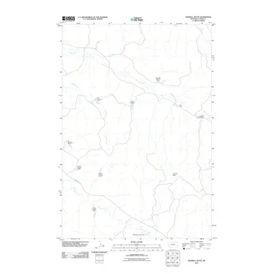
2011 Map of Maxwell Butte
USGS Topo · Published 2011About this map
Maxwell Butte stands as the primary landmark in this ranchland region of Custer County, where the management of water resources is paramount to the local economy. The landscape is defined by an intricate network of small reservoirs and earthen structures, many bearing family names such as the Rafferty and Fox series, as well as the Robinson and L Krutzfeldt dams. These features emphasize the reliance on seasonal drainages like Elmhurst Creek, Lindsey Creek, and Spring Creek for livestock and agriculture in a semi-arid environment. Infrastructure is sparse, anchored by the long stretch of Powderville Rd which provides the main transit corridor through the rolling terrain. This 2011 survey documents a modern snapshot of traditional Montana land use, where geographic naming conventions often reflect the legacy of local landholders and the vital necessity of water storage.
Find a feature on this map
16 named features on this map. Tap any name to fly to it.
Don’t see what you’re looking for? This feature index may not catch every label — zoom into the map to look around manually.
Map Details
Editions of this 2011 Maxwell Butte Map
This is the sole edition of this map. No revisions or reprints were ever made.
Other maps of this area

1953 · Miles City
USGS Topo · 1:250,000

1954 · Ekalaka
USGS Topo · 1:250,000

1956 · Ekalaka
USGS Topo · 1:250,000

1957 · Miles City
USGS Topo · 1:250,000

1958 · Miles City
USGS Topo · 1:250,000

1958 · Ekalaka
USGS Topo · 1:250,000

1965 · Ekalaka
USGS Topo · 1:250,000

1969 · Forty Creek
USGS Topo · 1:24,000

1969 · Miles City Creek
USGS Topo · 1:24,000
1969 · Bear Jaw Creek
USGS Topo · 1:24,000