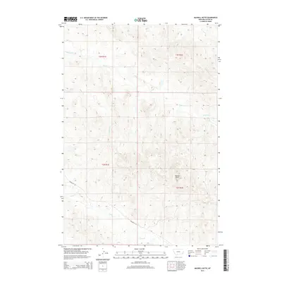
2014 Map of Maxwell Butte
USGS Topo · Published 2014About this map
Maxwell Butte rises above the high plains of Custer County, serving as a primary landmark in a landscape defined by its drainage systems and section lines. This 2014 survey documents the remote character of southeastern Montana, where Powderville Rd provides the principal overland route through the terrain. The map tracks the winding paths of several seasonal waterways, including Spring Cr and Elmhurst Cr, which carve through the breaks and coulees typical of the region's geography. Other notable drainages such as Lindsey Cr and Hercules Cr further illustrate the watershed patterns that dictate land use in these townships. While the area remains largely open, the grid of the Public Land Survey System, including t3n r51e and t2n r52e, establishes the framework for ranching and land ownership across this part of the state.
Find a feature on this map
10 named features on this map. Tap any name to fly to it.
Don’t see what you’re looking for? This feature index may not catch every label — zoom into the map to look around manually.
Map Details
Editions of this 2014 Maxwell Butte Map
This is the sole edition of this map. No revisions or reprints were ever made.
Other maps of this area

1953 · Miles City
USGS Topo · 1:250,000

1954 · Ekalaka
USGS Topo · 1:250,000

1956 · Ekalaka
USGS Topo · 1:250,000

1957 · Miles City
USGS Topo · 1:250,000

1958 · Miles City
USGS Topo · 1:250,000

1958 · Ekalaka
USGS Topo · 1:250,000

1965 · Ekalaka
USGS Topo · 1:250,000

1969 · Forty Creek
USGS Topo · 1:24,000

1969 · Miles City Creek
USGS Topo · 1:24,000
1969 · Bear Jaw Creek
USGS Topo · 1:24,000