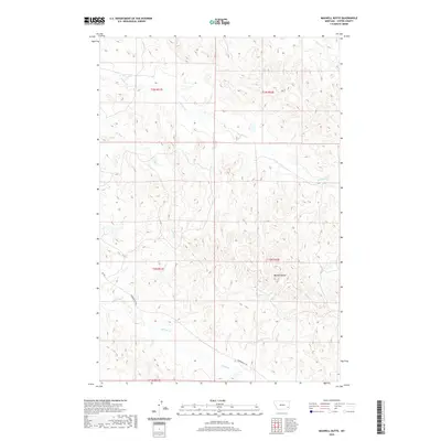
2020 Map of Maxwell Butte
USGS Topo · Published 2020About this map
Maxwell Butte stands as a primary landmark in this section of Custer County, overlooking a network of ephemeral drainage systems and rural transport routes. The landscape is defined by the headwaters and winding paths of Spring Creek, Lindsey Creek, and Elmhurst Creek, which carve through the high plains of eastern Montana. Human presence is marked by the long-established path of Powderville Rd, a vital local artery that connects disparate ranching parcels across townships including t2n r51e and t2n r52e. This topographic record provides a clear view of the complex terrain and seasonal water patterns that continue to shape the ranching and land-management practices in this isolated part of the state, serving as a reliable guide for understanding the relationship between the regional hydrology and the early 21st-century road network.
Find a feature on this map
12 named features on this map. Tap any name to fly to it.
Don’t see what you’re looking for? This feature index may not catch every label — zoom into the map to look around manually.
Map Details
Editions of this 2020 Maxwell Butte Map
This is the sole edition of this map. No revisions or reprints were ever made.
Other maps of this area

1953 · Miles City
USGS Topo · 1:250,000

1954 · Ekalaka
USGS Topo · 1:250,000

1956 · Ekalaka
USGS Topo · 1:250,000

1957 · Miles City
USGS Topo · 1:250,000

1958 · Miles City
USGS Topo · 1:250,000

1958 · Ekalaka
USGS Topo · 1:250,000

1965 · Ekalaka
USGS Topo · 1:250,000

1969 · Forty Creek
USGS Topo · 1:24,000

1969 · Miles City Creek
USGS Topo · 1:24,000
1969 · Bear Jaw Creek
USGS Topo · 1:24,000