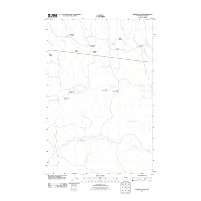
2011 Map of Maxwell Coulee
USGS Topo · Published 2011About this map
Van Norman serves as the primary junction in this Garfield County landscape, where the vast drainage systems of the eastern Montana plains intersect. The area is defined by an intricate network of seasonal watercourses and coulees, including Maxwell Coulee, Carcass Coulee, and Seven Tree Coulee, which feed into the larger Big Dry Creek and Kelly Creek basins. This 2011 survey documents a specialized hydraulic landscape engineered for water management in an arid environment. A series of earthen structures, such as the Wild Horse Reservoir Dam, USA Reservoir Number 2 Dam, and Rosa Spring Dam Number 1, illustrate the vital role of water storage for local agriculture and livestock. The naming conventions, from Jock Coulee to Peden Coulee, reflect the family-based geography common to the high plains, providing a precise record of historical land use and topographical identification.
Find a feature on this map
19 named features on this map. Tap any name to fly to it.
Don’t see what you’re looking for? This feature index may not catch every label — zoom into the map to look around manually.
Map Details
Editions of this 2011 Maxwell Coulee Map
This is the sole edition of this map. No revisions or reprints were ever made.
Other maps of this area

1954 · Jordan
USGS Topo · 1:250,000

1956 · Jordan
USGS Topo · 1:250,000

1958 · Jordan
USGS Topo · 1:250,000

1964 · Jordan
USGS Topo · 1:250,000

1964 · Ada Creek
USGS Topo · 1:24,000

1964 · Bateman Coulee NE
USGS Topo · 1:24,000

1965 · Whiteside Ranch
USGS Topo · 1:24,000

1965 · Hafla School
USGS Topo · 1:24,000
1965 · Cohagen NE
USGS Topo · 1:24,000

1967 · Hagen Gap
USGS Topo · 1:24,000