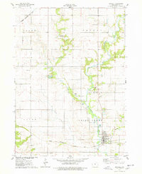
1975 Map of Maxwell
USGS Topo · Published 1978About this map
Maxwell sits along the southern edge of this mid-1970s survey, defined by the grid of its residential streets and the path of the Chicago Milwaukee St Paul and Pacific railroad. The landscape is dominated by the branching drainage system of Indian Creek and its tributaries, including West Indian Creek and Calamus Creek. To the north, the small community of Iowa Center and the residential development at Robison-Whitaker Acres appear as outliers in a primarily agricultural region. Several historical burial grounds are dispersed throughout the townships, including Pleasant Run Cem, Woodland Cem, and Center Grove Cem, providing valuable touchpoints for genealogists. The topography is also shaped by industrial and recreational sites, such as the various Gravel Pit locations along the creek beds and the Indian Creek Country Club situated near the intersection of the Grant and Nevada township lines.
Find a feature on this map
19 named features on this map. Tap any name to fly to it.
Don’t see what you’re looking for? This feature index may not catch every label — zoom into the map to look around manually.
Map Details
Editions of this 1975 Maxwell Map
This is the sole edition of this map. No revisions or reprints were ever made.
Other maps of this area

1911 · Slater
USGS Topo · 1:62,500

1912 · Ames
USGS Topo · 1:62,500

1913 · Slater
USGS Topo · 1:62,500

1914 · Ames
USGS Topo · 1:62,500

1954 · Waterloo
USGS Topo · 1:250,000

1954 · Des Moines
USGS Topo · 1:250,000

1955 · Waterloo
USGS Topo · 1:250,000

1956 · Des Moines
USGS Topo · 1:250,000

1957 · Des Moines
USGS Topo · 1:250,000

1969 · Des Moines
USGS Topo · 1:250,000