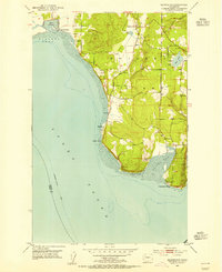
1953 Map of Maxwelton
USGS Topo · Published 1955About this map
Whidbey Island's southern tip is defined by a complex shoreline of points and bays, as shown in this early 1950s survey. The landscape transitions from the marshy depths of Deer Lagoon, protected by a Levee and Tide Gate, to the residential clustering at Sunlight Beach along the northern curve of Useless Bay. Local commerce and community centers appear at Maxwelton and Midvale Corner, while the island's eastern flank is marked by the small settlement of Possession overlooking the shipping lanes. The interior terrain is dotted with small bodies of water like Miller Lake and Deer Lake, interspersed with resource sites such as a Gravel Pit. The map also captures the maritime connectivity of the era, noting the Vancouver - Seattle Ferry route crossing through Puget Sound.
Find a feature on this map
19 named features on this map. Tap any name to fly to it.
Don’t see what you’re looking for? This feature index may not catch every label — zoom into the map to look around manually.
Map Details
Editions of this 1953 Maxwelton Map
4 editions found
Other maps of this area

1895 · Snohomish
USGS Topo · 1:125,000

1897 · Seattle
USGS Topo · 1:125,000

1911 · Mount Vernon
USGS Topo · 1:125,000

1937 · Port Gamble
USGS Topo · 1:62,500

1939 · Coupeville
USGS Topo · 1:62,500

1940 · Port Gamble
USGS Topo · 1:62,500

1942 · Edmonds
USGS Topo · 1:62,500

1943 · Stanwood
USGS Topo · 1:62,500

1953 · Hansville
USGS Topo · 1:24,000

1953 · Freeland
USGS Topo · 1:24,000