
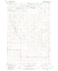
1982 Map of May Lake SW
USGS Topo · Published 1983About this map
McIntosh County prairie lands are defined by a complex network of glacial depressions and small wetlands in this early 1980s topographical study. The rural landscape is largely characterized by section-line roads and scattered agricultural activity, with several Gravel Pits distributed across the terrain. For genealogists and local historians, the map identifies two significant burial sites: New Kassel Cem and Kassel Cem. These locations serve as primary indicators of the German-Russian heritage common to this region of North Dakota, marking the site of early community gathering points that supported the surrounding farmsteads. The sparse distribution of named features highlights the quiet, open character of the Great Plains before modern consolidation shifted the local population patterns.
Find a feature on this map
3 named features on this map. Tap any name to fly to it.
Don’t see what you’re looking for? This feature index may not catch every label — zoom into the map to look around manually.
Map Details
Editions of this 1982 May Lake SW Map
This is the sole edition of this map. No revisions or reprints were ever made.
Other maps of this area

1953 · Jamestown
USGS Topo · 1:250,000

1954 · Aberdeen
USGS Topo · 1:250,000

1956 · Aberdeen
USGS Topo · 1:250,000

1956 · Jamestown
USGS Topo · 1:250,000

1978 · Greenway
USGS Topo · 1:24,000

1978 · Zeeland
USGS Topo · 1:24,000

1978 · Venturia
USGS Topo · 1:24,000
1980 · Hague SE
USGS Topo · 1:24,000

1982 · May Lake NW
USGS Topo · 1:24,000

1982 · May Lake
USGS Topo · 1:24,000