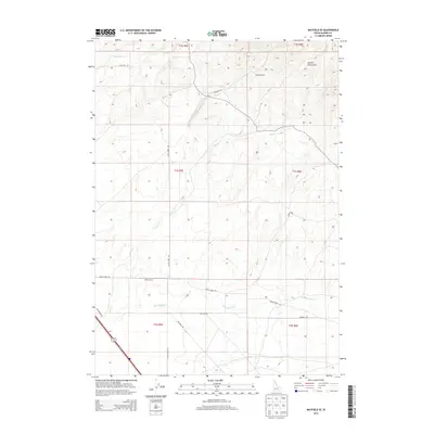
2013 Map of Mayfield SE
USGS Topo · Published 2013About this map
The Danskin Mountains dominate the northeastern portion of this Elmore County landscape, where the high terrain gives way to a network of seasonal drainages and ranching corridors. The area is defined by its water sources, with Soles Rest Cr, Ditto Cr, and Squaw Cr carving through the arid hills. Human presence is centered on established homesteads such as Bennett Ranch and Willow Ranch, which are connected by a grid of rural thoroughfares including Squaw Creek Rd and Ditto Creek Rd. In the southwest corner, the corridor of Old Highway 30 traces the path of earlier transcontinental travel. This survey illustrates the persistent ranching economy and the importance of spring-fed features like Mud Springs Cr in sustaining life and livestock in the high desert.
Find a feature on this map
22 named features on this map. Tap any name to fly to it.
Don’t see what you’re looking for? This feature index may not catch every label — zoom into the map to look around manually.
Map Details
Editions of this 2013 Mayfield SE Map
This is the sole edition of this map. No revisions or reprints were ever made.
Other maps of this area

1892 · Mountain Home
USGS Topo · 1:125,000

1893 · Mountain Home
USGS Topo · 1:125,000

1955 · Hailey
USGS Topo · 1:250,000
1956 · Cinder Cone Butte
USGS Topo · 1:24,000

1956 · Crater Rings
USGS Topo · 1:24,000

1956 · Mountain Home North
USGS Topo · 1:24,000

1956 · Mountain Home
USGS Topo · 1:62,500

1959 · Hailey
USGS Topo · 1:250,000

1960 · Mayfield
USGS Topo · 1:62,500

1960 · Danskin Peak
USGS Topo · 1:62,500