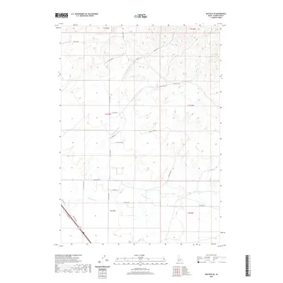
2020 Map of Mayfield SE
USGS Topo · Published 2020About this map
Mud Springs Cr and Ditto Cr define the drainage patterns of this high-desert landscape in Elmore County. The area is characterized by a grid of rural lanes and ranch roads that follow the section lines of the Public Land Survey System, including Base Line Rd and Ditto Creek Rd. In the southwestern corner, the transportation corridor of Old Hwy 30 and Frontage Rd cuts across the terrain, reflecting the modern evolution of regional travel routes. While primarily open country, the map documents the network of family-named lanes such as E Rumsey Ln and W Wayno Rd, which provide evidence of local landownership and agricultural settlement. The confluence of seasonal watercourses like Dry Cr and Squaw Cr against the surveyed boundaries of t1s r5e illustrates the intersection of natural topography and human administrative order.
Find a feature on this map
25 named features on this map. Tap any name to fly to it.
Don’t see what you’re looking for? This feature index may not catch every label — zoom into the map to look around manually.
Map Details
Editions of this 2020 Mayfield SE Map
This is the sole edition of this map. No revisions or reprints were ever made.
Other maps of this area

1892 · Mountain Home
USGS Topo · 1:125,000

1893 · Mountain Home
USGS Topo · 1:125,000

1955 · Hailey
USGS Topo · 1:250,000
1956 · Cinder Cone Butte
USGS Topo · 1:24,000

1956 · Crater Rings
USGS Topo · 1:24,000

1956 · Mountain Home North
USGS Topo · 1:24,000

1956 · Mountain Home
USGS Topo · 1:62,500

1959 · Hailey
USGS Topo · 1:250,000

1960 · Mayfield
USGS Topo · 1:62,500

1960 · Danskin Peak
USGS Topo · 1:62,500