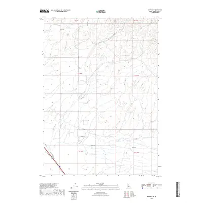
2023 Map of Mayfield SE
USGS Topo · Published 2023About this map
The Danskin Mountains dominate the northeastern portion of this Elmore County landscape, where the high terrain gives way to a network of seasonal drainages including Soles Rest Creek, Ditto Creek, and Dry Creek. The southern reach of the map transitions into a more structured grid of rural access roads and transportation corridors. This area is characterized by long-established survey lines like Base Line Rd and the historical path of Old Hwy 30 in the southwest corner. Local movement across the high desert and foothills is traced by a mix of named avenues and descriptive routes, such as Slater Flat Rd and the intriguing Kwahate Naokwaide. This documentation of the land reveals a workspace of ranching and remote infrastructure, where small tributaries like Mud Springs Creek define the natural flow of the high basin floor.
Find a feature on this map
25 named features on this map. Tap any name to fly to it.
Don’t see what you’re looking for? This feature index may not catch every label — zoom into the map to look around manually.
Map Details
Editions of this 2023 Mayfield SE Map
This is the sole edition of this map. No revisions or reprints were ever made.
Other maps of this area

1892 · Mountain Home
USGS Topo · 1:125,000

1893 · Mountain Home
USGS Topo · 1:125,000

1955 · Hailey
USGS Topo · 1:250,000
1956 · Cinder Cone Butte
USGS Topo · 1:24,000

1956 · Crater Rings
USGS Topo · 1:24,000

1956 · Mountain Home North
USGS Topo · 1:24,000

1956 · Mountain Home
USGS Topo · 1:62,500

1959 · Hailey
USGS Topo · 1:250,000

1960 · Mayfield
USGS Topo · 1:62,500

1960 · Danskin Peak
USGS Topo · 1:62,500