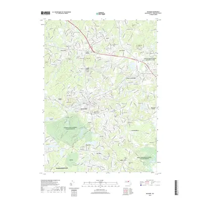
2018 Map of Maynard
USGS Topo · Published 2018About this map
Maynard and the surrounding township of Acton are defined by the convergence of the Assabet River and several glacial hills, including Faulkner Hill and Vose Hill. This modern survey illustrates how preservation lands like the Assabet River National Wildlife Refuge and Great Meadows National Wildlife Refuge now border established suburban corridors and industrial remnants. The landscape is dotted with several significant burial grounds, from the large Glenwood Cem to the smaller Three Cornered Cem and North Sudbury Cem. Small private aviation history is preserved at Sids Airport and Crow Island Airport, while the eastern edge of the map touches the hallowed grounds of Minute Man National Historical Park. Along the river and its many tributaries like Fort Pond Brook, the map records the enduring character of a region that balances its Revolutionary War-era roots with modern development and conservation.
Find a feature on this map
79 named features on this map. Tap any name to fly to it.
Don’t see what you’re looking for? This feature index may not catch every label — zoom into the map to look around manually.
Map Details
Editions of this 2018 Maynard Map
This is the sole edition of this map. No revisions or reprints were ever made.
Other maps of this area

1886 · Lowell
USGS Topo · 1:62,500

1886 · Framingham
USGS Topo · 1:62,500

1887 · Marlboro
USGS Topo · 1:62,500

1889 · Marlboro
USGS Topo · 1:62,500

1889 · Framingham
USGS Topo · 1:62,500

1893 · Lowell
USGS Topo · 1:62,500

1893 · Groton
USGS Topo · 1:62,500

1894 · Framingham
USGS Topo · 1:62,500

1896 · Marlboro
USGS Topo · 1:62,500

1898 · Marlboro
USGS Topo · 1:62,500