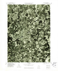
1977 Map of Maynard
USGS Topo · Published 1981About this map
Maynard and its surrounding mill-town landscapes are captured here in the late 1970s through high-altitude aerial photography. This orthophotoquad reveals the intricate residential expansion and industrial footprint of Acton and West Concord as they appeared just before the digital age reshaped the region's economy. The Assabet River winds through the center of the sheet, providing a geographic anchor for the dense settlement patterns in South Acton and West Acton. Researchers can observe the interplay between the established town centers and the encroaching suburban developments that began to define eastern Massachusetts during this era. The map also includes portions of Sudbury, documenting the balance of wooded acreage and modern infrastructure that characterized the suburban sprawl of the late twentieth century.
Find a feature on this map
7 named features on this map. Tap any name to fly to it.
Don’t see what you’re looking for? This feature index may not catch every label — zoom into the map to look around manually.
Map Details
Editions of this 1977 Maynard Map
This is the sole edition of this map. No revisions or reprints were ever made.
Other maps of this area

1886 · Lowell
USGS Topo · 1:62,500

1886 · Framingham
USGS Topo · 1:62,500

1887 · Marlboro
USGS Topo · 1:62,500

1889 · Marlboro
USGS Topo · 1:62,500

1889 · Framingham
USGS Topo · 1:62,500

1893 · Lowell
USGS Topo · 1:62,500

1893 · Groton
USGS Topo · 1:62,500

1894 · Framingham
USGS Topo · 1:62,500

1896 · Marlboro
USGS Topo · 1:62,500

1898 · Marlboro
USGS Topo · 1:62,500