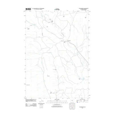
2012 Map of Mayoworth
USGS Topo · Published 2012About this map
The N Fork Powder River carves a central path through this Wyoming landscape, where the settlement of Mayoworth serves as a focal point for a region defined by ranching and high-desert terrain. Settled families and long-standing land holdings are evidenced by named properties such as the Smith Ranch, Gordon Ranch, and Chubb and Lloyd Ranch. The presence of the Morgareidge Cem near Charlie House Draw provides a genealogical touchstone for researchers tracing the history of Johnson County's early pioneers.
Find a feature on this map
33 named features on this map. Tap any name to fly to it.
Don’t see what you’re looking for? This feature index may not catch every label — zoom into the map to look around manually.
Map Details
Editions of this 2012 Mayoworth Map
This is the sole edition of this map. No revisions or reprints were ever made.
Other maps of this area

1955 · Arminto
USGS Topo · 1:250,000

1958 · Arminto
USGS Topo · 1:250,000

1961 · Barnum
USGS Topo · 1:62,500

1961 · Schlict Draw
USGS Topo · 1:24,000

1961 · Hibbard Draw
USGS Topo · 1:24,000

1961 · Kaycee
USGS Topo · 1:24,000

1962 · Arminto
USGS Topo · 1:250,000

1963 · Mayoworth
USGS Topo · 1:62,500
1979 · Red Fork Powder River
USGS Topo · 1:24,000
1979 · Mayoworth
USGS Topo · 1:24,000