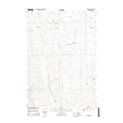
2015 Map of Mayoworth
USGS Topo · Published 2015About this map
The settlement of Mayoworth sits at the center of an intricate irrigation network in Johnson County, where the High Plains meet the eastern slopes of the Bighorn Mountains. Water management is the primary human imprint on this landscape, visible through the complex system of the Morgareidge Ditch, Barrett Ditch, Capitola Ditch, and Strickler-Rinker-Ditch, which divert the flows of the N Fork Powder River and its tributaries to support local ranching.
Find a feature on this map
34 named features on this map. Tap any name to fly to it.
Don’t see what you’re looking for? This feature index may not catch every label — zoom into the map to look around manually.
Map Details
Editions of this 2015 Mayoworth Map
This is the sole edition of this map. No revisions or reprints were ever made.
Other maps of this area

1955 · Arminto
USGS Topo · 1:250,000

1958 · Arminto
USGS Topo · 1:250,000

1961 · Barnum
USGS Topo · 1:62,500

1961 · Schlict Draw
USGS Topo · 1:24,000

1961 · Hibbard Draw
USGS Topo · 1:24,000

1961 · Kaycee
USGS Topo · 1:24,000

1962 · Arminto
USGS Topo · 1:250,000

1963 · Mayoworth
USGS Topo · 1:62,500
1979 · Red Fork Powder River
USGS Topo · 1:24,000
1979 · Mayoworth
USGS Topo · 1:24,000