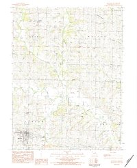
1983 Map of Maysville
USGS Topo · Published 1984About this map
The county seat of Maysville serves as the focal point for this DeKalb County survey, where the township grid system divides the rural landscape into the territories of Grant, Dallas, Camden, and Adams. The drainage pattern is defined by the Middle Fork and East Fork of the Grand River, creating a network of winding tributaries like Lost Creek and Noll Branch. A notable vestige of earlier transportation is the Old Railroad Grade traversing the southern portion of the quadrangle, signaling a shift from rail-based commerce to the modern road network.
Find a feature on this map
29 named features on this map. Tap any name to fly to it.
Don’t see what you’re looking for? This feature index may not catch every label — zoom into the map to look around manually.
Map Details
Editions of this 1983 Maysville Map
This is the sole edition of this map. No revisions or reprints were ever made.
Other maps of this area

1923 · Maysville
USGS Topo · 1:62,500

1924 · Winston
USGS Topo · 1:62,500

1925 · Pattonsburg
USGS Topo · 1:62,500

1925 · Maysville
USGS Topo · 1:62,500

1925 · Darlington
USGS Topo · 1:62,500

1944 · Pattonsburg
USGS Topo · 1:62,500

1946 · Pattonsburg
USGS Topo · 1:48,000

1948 · Pattonsburg
USGS Topo · 1:62,500

1950 · Kansas City
USGS Topo · 1:250,000

1950 · Darlington
USGS Topo · 1:62,500