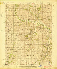
1925 Map of Maysville
USGS Topo · Published 1925About this map
Maysville serves as the central hub of this DeKalb County landscape, where the Chicago Rock Island and Pacific railroad bisects the terrain. The 1920s countryside is densely populated with a network of rural schoolhouses and churches, reflecting a tightly knit agrarian society. Notable local landmarks include the Amity Cemetery and the Butler Cemetery, which offer significant value for genealogical research. The topography is defined by the winding course of the Platte River and its tributaries like Lost Creek and Owens Creek. Further south, the Chicago Burlington and Quincy line passes through Osborn, connecting the smaller settlements of Amity and Fairport to the broader regional economy. This survey documents an era before modern school consolidation, preserving the names of dozens of local institutions such as New Harvard School and Garden Prairie School.
Find a feature on this map
67 named features on this map. Tap any name to fly to it.
Don’t see what you’re looking for? This feature index may not catch every label — zoom into the map to look around manually.
Map Details
Editions of this 1925 Maysville Map
2 editions found
Other maps of this area

1923 · Clarksdale
USGS Topo · 1:62,500

1923 · Maysville
USGS Topo · 1:62,500

1924 · Polo
USGS Topo · 1:62,500

1924 · Winston
USGS Topo · 1:62,500

1925 · Pattonsburg
USGS Topo · 1:62,500

1925 · Gower
USGS Topo · 1:62,500

1925 · Clarksdale
USGS Topo · 1:62,500

1925 · Plattsburg
USGS Topo · 1:62,500

1925 · Stanberry
USGS Topo · 1:62,500

1925 · Maysville
USGS Topo · 1:62,500