
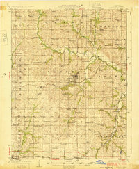
1925 Map of Maysville
USGS Topo · Published 1925About this map
Maysville serves as the central hub of this DeKalb County landscape, where the Chicago Rock Island and Pacific railroad intersects with a dense network of early 20th-century rural infrastructure. The map reveals an exceptionally high concentration of neighborhood institutions, with nearly every section of land supporting a named schoolhouse or church. From Waldo School in the northwest to the Garden Prairie School in the south, these sites delineate the social geography of the era. The terrain is defined by the branching tributaries of the Little Platte River and Castile Creek, which dictated the placement of early settlements like Amity and Osborn. Significant genealogical markers are documented at Butler Cemetery and Amity Cemetery, providing fixed points for local history researchers.
Find a feature on this map
70 named features on this map. Tap any name to fly to it.
Don’t see what you’re looking for? This feature index may not catch every label — zoom into the map to look around manually.
Map Details
Editions of this 1925 Maysville Map
2 editions found
Other maps of this area

1923 · Clarksdale
USGS Topo · 1:62,500

1923 · Maysville
USGS Topo · 1:62,500

1924 · Polo
USGS Topo · 1:62,500

1924 · Winston
USGS Topo · 1:62,500

1925 · Pattonsburg
USGS Topo · 1:62,500

1925 · Gower
USGS Topo · 1:62,500

1925 · Clarksdale
USGS Topo · 1:62,500

1925 · Plattsburg
USGS Topo · 1:62,500

1925 · Stanberry
USGS Topo · 1:62,500

1925 · Darlington
USGS Topo · 1:62,500