
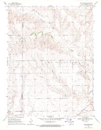
1969 Map of Mc Allaster NW
USGS Topo · Published 1971About this map
The South Fork Solomon River flows across the northern edge of this Kansas landscape, while the Smoky Hill River cuts through the southwestern corner, marking a significant hydrologic divide in the High Plains. Surveyed in the late 1960s, the terrain is defined by the high tablelands of Iowa and Mc Allaster, where the drainage patterns of Sand Creek have carved deep contours into the earth. The map reveals the functional infrastructure of the rural west, including a spillway and a remote Jeep Trail traversing the open range. Bordered by several county lines, including the junction of Sherman, Wallace, and Logan counties, the map captures a period of active land use evidenced by scattered gravel pits and isolated water wells.
Find a feature on this map
14 named features on this map. Tap any name to fly to it.
Don’t see what you’re looking for? This feature index may not catch every label — zoom into the map to look around manually.
Map Details
Editions of this 1969 Mc Allaster NW Map
This is the sole edition of this map. No revisions or reprints were ever made.
Other maps of this area

1954 · Goodland
USGS Topo · 1:250,000

1956 · Goodland
USGS Topo · 1:250,000

1957 · Goodland
USGS Topo · 1:250,000

1959 · Harris Draw
USGS Topo · 1:62,500

1966 · Edson
USGS Topo · 1:24,000

1966 · Brewster
USGS Topo · 1:24,000

1966 · Brewster SE
USGS Topo · 1:24,000

1969 · Mc Allaster SE
USGS Topo · 1:24,000

1969 · Mc Allaster NE
USGS Topo · 1:24,000
1969 · Mc Allaster
USGS Topo · 1:24,000