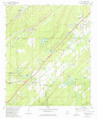
1980 Map of Mc Calla
USGS Topo · Published 1980About this map
The industrial and agricultural landscapes of western Jefferson and eastern Tuscaloosa Counties are defined here by a series of parallel ridges, including Rock Mountain, Red Mountain, and Shades Mountain. These geologic formations separate distinct valleys like Jones Valley and Shades Valley, where the 1980 survey shows the intersection of heavy industry and rural community life. Large-scale Strip Mine operations and several Chert Pit locations are prominent near North Johns and Adger, marking the region's historical reliance on coal and mineral extraction.
Find a feature on this map
59 named features on this map. Tap any name to fly to it.
Don’t see what you’re looking for? This feature index may not catch every label — zoom into the map to look around manually.
Map Details
Editions of this 1980 Mc Calla Map
2 editions found
Other maps of this area

1890 · Bessemer
USGS Topo · 1:125,000

1892 · Bessemer
USGS Topo · 1:125,000

1899 · Brookwood
USGS Topo · 1:125,000

1905 · Bessemer Iron District
USGS Topo · 1:62,500

1907 · Bessemer Special
USGS Topo · 1:62,500

1910 · Montevallo
USGS Topo · 1:62,500

1927 · Adger
USGS Topo · 1:48,000

1932 · Yolande
USGS Topo · 1:62,500

1934 · Blocton
USGS Topo · 1:48,000

1935 · Yolande
USGS Topo · 1:62,500