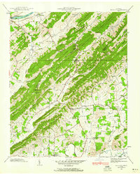
1939 Map of Mc Cloud
USGS Topo · Published 1960About this map
The Hawkins and Greene County border runs through a ridge-and-valley landscape dominated by the parallel rises of Bays Mountain and Cove Mountain. Settlement in 1939 follows the fertile lowlands of Carter Valley and the banks of the Holston River, where the Southern Railroad passes through Arnotts and past McDonald Mill. This survey captures a dense network of rural community centers, including Sanders Chapel School, Dodson Creek Chapel, and the village of Romeo. Aviation history is visible via the High Airway Beacon Spur near Louderback Gap, while family history is preserved in numerous scattered burial grounds like Patterson Cemetery and the Dodson Creek Cemetery. The terrain is deeply carved by water, from the Lick Creek drainage in the south to the northern Dodson Creek valley.
Find a feature on this map
86 named features on this map. Tap any name to fly to it.
Don’t see what you’re looking for? This feature index may not catch every label — zoom into the map to look around manually.
Map Details
Editions of this 1939 Mc Cloud Map
This is the sole edition of this map. No revisions or reprints were ever made.
Other maps of this area

1883 · Morristown
USGS Topo · 1:125,000

1892 · Greeneville
USGS Topo · 1:125,000

1893 · Morristown
USGS Topo · 1:125,000

1895 · Morristown
USGS Topo · 1:125,000

1896 · Greeneville
USGS Topo · 1:125,000

1904 · Greeneville
USGS Topo · 1:125,000

1935 · Surgoinsville
USGS Topo · 1:48,000

1935 · Baileyton
USGS Topo · 1:24,000

1935 · Rogersville
USGS Topo · 1:48,000

1935 · McCloud
USGS Topo · 1:24,000