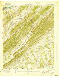
1940 Map of Mc Cloud
USGS Topo · Published 1940About this map
The Hawkins Co Greene Co line cuts diagonally across this 1940 topographic landscape, where the rugged ridges of the Bays Mountains and Dodson Mountain dictate the flow of rural life. In the north, the Southern railroad follows the Holston River past the small settlement of Arnotts and the industrial landmark of McDonald Mill. The map reveals a high density of community centers, schools, and family cemeteries that defined this era of East Tennessee agriculture.
Find a feature on this map
77 named features on this map. Tap any name to fly to it.
Don’t see what you’re looking for? This feature index may not catch every label — zoom into the map to look around manually.
Map Details
Editions of this 1940 Mc Cloud Map
This is the sole edition of this map. No revisions or reprints were ever made.
Other maps of this area

1883 · Morristown
USGS Topo · 1:125,000

1892 · Greeneville
USGS Topo · 1:125,000

1893 · Morristown
USGS Topo · 1:125,000

1895 · Morristown
USGS Topo · 1:125,000

1896 · Greeneville
USGS Topo · 1:125,000

1904 · Greeneville
USGS Topo · 1:125,000

1935 · Surgoinsville
USGS Topo · 1:48,000

1935 · Baileyton
USGS Topo · 1:24,000

1935 · Rogersville
USGS Topo · 1:48,000

1935 · McCloud
USGS Topo · 1:24,000