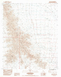
1983 Map of Mc Coy Peak
USGS Topo · Published 1983About this map
The Mc Coy Mountains dominate this 1980s landscape in Riverside County, rising sharply from the surrounding desert floor. This region is defined by its arid drainage patterns and industrial exploration, where a network of Dry Wash channels and the larger Mc Coy Wash move sediment toward the basin. The high peaks, including Mc Coy Peak and Mc Coy Mountain, provide significant topographic relief in an area otherwise marked by remote activity. Evidence of late 20th-century resource extraction and surveying is visible through scattered Prospects, a Borrow Pit, and a designated Drill Hole. Access into the interior is limited, largely dependent on a rugged Jeep Trail that skirts the southern foothills near West Mc Coy.
Find a feature on this map
10 named features on this map. Tap any name to fly to it.
Don’t see what you’re looking for? This feature index may not catch every label — zoom into the map to look around manually.
Map Details
Editions of this 1983 Mc Coy Peak Map
This is the sole edition of this map. No revisions or reprints were ever made.
Other maps of this area

1942 · Blythe
USGS Topo · 1:250,000

1945 · Big Maria Mtns
USGS Topo · 1:62,500

1945 · Midland
USGS Topo · 1:62,500

1951 · Big Maria Mts
USGS Topo · 1:62,500

1951 · McCoy Wash
USGS Topo · 1:24,000

1952 · Midland
USGS Topo · 1:62,500

1952 · Mc Coy Spring
USGS Topo · 1:62,500

1952 · Ripley
USGS Topo · 1:24,000

1954 · Salton Sea
USGS Topo · 1:250,000

1955 · Salton Sea
USGS Topo · 1:250,000