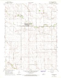
1965 Map of Mc Cracken
USGS Topo · Published 1967About this map
McCracken serves as the central hub for this portion of the Kansas plains during the mid-1960s, situated at the intersection of local township boundaries. The town is defined by its position along the Missouri Pacific railroad, which cuts through the landscape near several prominent watercourses including Snake Creek and Big Timber Creek. This survey reveals an economy transitioning between traditional agriculture and resource extraction, evidenced by the presence of a Sandpit and scattered oil wells, particularly in the southern reaches near Alexander Creek. Genealogists will find the local burial grounds, including McCracken Cem and a smaller unnamed cem, clearly marked. The topography is further categorized by historical administrative divisions, spanning the townships of Waring, Hampton, Alexander, and Bazine.
Find a feature on this map
16 named features on this map. Tap any name to fly to it.
Don’t see what you’re looking for? This feature index may not catch every label — zoom into the map to look around manually.
Map Details
Editions of this 1965 Mc Cracken Map
This is the sole edition of this map. No revisions or reprints were ever made.
Other maps of this area

1889 · Larned
USGS Topo · 1:125,000

1891 · Larned
USGS Topo · 1:125,000

1892 · Ness
USGS Topo · 1:125,000

1893 · Ellis
USGS Topo · 1:125,000

1894 · Ness
USGS Topo · 1:125,000
1896 · Hays
USGS Topo · 1:125,000

1955 · Great Bend
USGS Topo · 1:250,000

1957 · Great Bend
USGS Topo · 1:250,000

1958 · Great Bend
USGS Topo · 1:250,000
1966 · Alexander
USGS Topo · 1:24,000